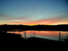
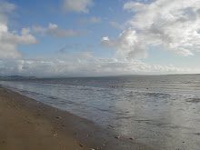
Beach Wetlands II
One of the great things about wetlands on the beach in prehistoric times is they were more than just wetlands, they were lakes. The land form of the beach is pretty much defined by north south dunes with swales between. The swales (wetland areas) also run north south. The swales tend to be low and very flat. That flat profile means that a fairly low head (low elevation) dam can flood a tremendous area. For example, a road about 18"-24" high that crosses a wetland can become a dike (look at a cranberry bog) and back up water in a hundred acre area. Of course, this is what beavers are so good at doing. They will build a series of dams and each dam has the capacity to raise the water level behind it 2 feet or more.
Now all these lakes had connections and with some creative portages over beaver dams and across the dunes, these connections formed an inter-dune lake system that was the backbone of travel for Chinook canoe paddlers as they traveled north and south in the lake system. In historic times, my fathers friend Ed Chellis commented that when the lakes froze north of Ocean Park, it was possible to ice skate from Ocean Park north towards Oysterville, then take off your skates, walk over the dunes and be in Oysterville. I've looked at the wetlands north of Ocean Park and sure enough, the wetland that is defined by the WPA ditch drains a wetland that connects north to Surfside (behind the golf course), then a short crossing over dune puts you in another wetland (Skating Lake..nice name) that connects north towards Oysterville Weatherbeach Road. During the cold weather in the late 60's, my family would join other families at Skating Lake for skate parties but once Surfside was built and an outfall was built to drain water away from Surfside (and towards Whisky Slough), this lake disappeared.
Friday, March 6, 2009
Tuesday, March 3, 2009
Beach Wetlands I
Beach Wetlands I
Ah..beach wetlands, by that I mean the wetlands on the Peninsula..all of them, the freshwater ones that are all over the place. My sister Kathleen and I've had an occasionally lively discussion on the pre-historic (that is like, 200+ years ago) size and make up of these wetlands.
Years ago when I was a young sprout I spent part of one summer participating in an archaeological dig up Nahcotta way yonder. Dr. Robert Shaw from WSU (he later went to Alaska from which I hear he's retired as the state archaeologist) was directing the dig as a post-doc under the tutelage of famed archy Dr. Daughtery. We were investigating a Chinook summer village located at the edge of a lake. The lake was no longer present, having been drained in historic times.
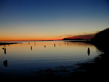
Now Kathleen's and my discussion centered around...how much water, particularly groundwater, was originally visible on the beach? Ground water becomes visible in the inter dune swales, the low spots between old (and new) dunes. Same place where cranberry bogs are as well as most of the beach wetlands.
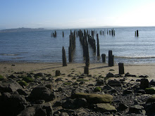
Prehistorically speaking, the beach drained naturally through the following sloughs: Loomis, Tarlett, Giles, Freshwater, Whiskey, Paul's, and Stackpole. What might a prehistoric sloug look like? Well go to Long Island and hike the logging road from Sawlog Slough to the Cedar Grove and peer at the beaver dam that appears on the north. Beavers built a dam literally at tidewater and that day I saw it, the tide was higher than the freshwater slough! We suspect that the beach was no different, thus at every slough, somewhere near tidewater, there was a beaver dam and low..the slough was dammed up.
What that meant is that the surface water discharge was substantially slowed. When you compare that with the present day situation..in which most of the sloughs are maintained as drainage ditches as well as many new ditches added (East Main, South Main, 30th Street outfall, Beard's hollow outfall, Surfside outfalls, WPA ditch, etc.), then the water retained was likely substantial. We can never really know but I can give you examples from the historic record.
The Shaegrun Ranch was located north of Joe Johns Road (the farm house still stands). A giant hay marsh was west of it in an area later known as Espy Lake. Espy Lake appears on early USGS topo maps as a lake. Today this area is a cranberry bog but years ago it was a lake. When the crew floods the bogs during harvest, well it returns to a lake for a day.
The upshot of all this is that it is very likely that the winter time water level was at least 3 feet higher than modern times. An example would be Al Shire's comment that in early Long Beach, you could row a small boat across Pacific Avenue at Bolstad. Go to Long Beach City Hall and look east towards Culbertson park, note the dip in the land, that's an old swale. If the very able public works crew at Long Beach didn't maintain there stormwater pumping system...in January, then it is likely you too could row across Long Beach.
By the way, in the summer during a low tide, you'll notice water draining away from the beach in seeps either along the bay or ocean, that water is groundwater draining downhill from points higher.
Ah..beach wetlands, by that I mean the wetlands on the Peninsula..all of them, the freshwater ones that are all over the place. My sister Kathleen and I've had an occasionally lively discussion on the pre-historic (that is like, 200+ years ago) size and make up of these wetlands.
Years ago when I was a young sprout I spent part of one summer participating in an archaeological dig up Nahcotta way yonder. Dr. Robert Shaw from WSU (he later went to Alaska from which I hear he's retired as the state archaeologist) was directing the dig as a post-doc under the tutelage of famed archy Dr. Daughtery. We were investigating a Chinook summer village located at the edge of a lake. The lake was no longer present, having been drained in historic times.
Now Kathleen's and my discussion centered around...how much water, particularly groundwater, was originally visible on the beach? Ground water becomes visible in the inter dune swales, the low spots between old (and new) dunes. Same place where cranberry bogs are as well as most of the beach wetlands.
Prehistorically speaking, the beach drained naturally through the following sloughs: Loomis, Tarlett, Giles, Freshwater, Whiskey, Paul's, and Stackpole. What might a prehistoric sloug look like? Well go to Long Island and hike the logging road from Sawlog Slough to the Cedar Grove and peer at the beaver dam that appears on the north. Beavers built a dam literally at tidewater and that day I saw it, the tide was higher than the freshwater slough! We suspect that the beach was no different, thus at every slough, somewhere near tidewater, there was a beaver dam and low..the slough was dammed up.
What that meant is that the surface water discharge was substantially slowed. When you compare that with the present day situation..in which most of the sloughs are maintained as drainage ditches as well as many new ditches added (East Main, South Main, 30th Street outfall, Beard's hollow outfall, Surfside outfalls, WPA ditch, etc.), then the water retained was likely substantial. We can never really know but I can give you examples from the historic record.
The Shaegrun Ranch was located north of Joe Johns Road (the farm house still stands). A giant hay marsh was west of it in an area later known as Espy Lake. Espy Lake appears on early USGS topo maps as a lake. Today this area is a cranberry bog but years ago it was a lake. When the crew floods the bogs during harvest, well it returns to a lake for a day.
The upshot of all this is that it is very likely that the winter time water level was at least 3 feet higher than modern times. An example would be Al Shire's comment that in early Long Beach, you could row a small boat across Pacific Avenue at Bolstad. Go to Long Beach City Hall and look east towards Culbertson park, note the dip in the land, that's an old swale. If the very able public works crew at Long Beach didn't maintain there stormwater pumping system...in January, then it is likely you too could row across Long Beach.
By the way, in the summer during a low tide, you'll notice water draining away from the beach in seeps either along the bay or ocean, that water is groundwater draining downhill from points higher.
Subscribe to:
Posts (Atom)
About Me

- Jim
- Seaview, Washington, United States
- I live a mile from where I was born but sometimes I feel like a stranger in my own strange land. Descendant from gold miners (The Yukon and Mexico), coal miners (Wales, British Columbia and Washington), timbermen (Sweden), sod and berry farmers (Missouri, Washington), Klondikers, fortune seekers and just plain hearty peasant stock.